Principal meridian: Difference between revisions
Jump to navigation
Jump to search

imported>Anthony Argyriou (cut redundant text) |
Pat Palmer (talk | contribs) m (Text replacement - "United States" to "United States of America") |
||
| (One intermediate revision by one other user not shown) | |||
| Line 1: | Line 1: | ||
{{subpages}} | |||
[[Image:Pmmap.jpg|thumb|404px|right| This BLM map depicts the principal meridians and [[baseline (surveying)|baselines]] used for surveying states (colored) in the PLSS.]] | [[Image:Pmmap.jpg|thumb|404px|right| This BLM map depicts the principal meridians and [[baseline (surveying)|baselines]] used for surveying states (colored) in the PLSS.]] | ||
In the [[United States]] [[Public Land Survey System]], a '''principal meridian''' is the [[meridian]] line used for survey control in a large region, and which divides townships between east and west. The meridian meets its corresponding [[baseline (surveying)|baseline]] at the point of origin, or '''initial point''', for the land survey. For example, the Mount Diablo Meridian, used for surveys in California and Nevada, runs through the summit of [[Mount Diablo State Park|Mount Diablo]]. | In the [[United States of America]] [[Public Land Survey System]], a '''principal meridian''' is the [[meridian]] line used for survey control in a large region, and which divides townships between east and west. The meridian meets its corresponding [[baseline (surveying)|baseline]] at the point of origin, or '''initial point''', for the land survey. For example, the Mount Diablo Meridian, used for surveys in California and Nevada, runs through the summit of [[Mount Diablo State Park|Mount Diablo]]. | ||
Often, meridians are marked with roads, such as the Meridian Avenue in [[San Jose, California]] and Meridian Road in [[Vacaville, California]], both on the Mount Diablo Meridian. | Often, meridians are marked with roads, such as the Meridian Avenue in [[San Jose, California]] and Meridian Road in [[Vacaville, California]], both on the Mount Diablo Meridian. | ||
Latest revision as of 14:13, 2 February 2023

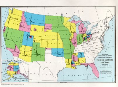
This BLM map depicts the principal meridians and baselines used for surveying states (colored) in the PLSS.
In the United States of America Public Land Survey System, a principal meridian is the meridian line used for survey control in a large region, and which divides townships between east and west. The meridian meets its corresponding baseline at the point of origin, or initial point, for the land survey. For example, the Mount Diablo Meridian, used for surveys in California and Nevada, runs through the summit of Mount Diablo.
Often, meridians are marked with roads, such as the Meridian Avenue in San Jose, California and Meridian Road in Vacaville, California, both on the Mount Diablo Meridian.