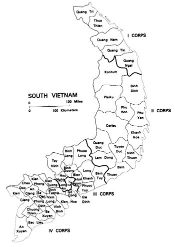
IV Corps tactical zone
Jump to navigation
Jump to search
During the Vietnam War, the IV Corps tactical zone (IV CTZ)[1] was an Army of the Republic of Viet Nam organization with geographic responsibility for the Mekong Delta provinces, including much of the classic area of Cochin China less the Saigon area. [2]
IV CTZ headquarters was at Can Tho. There was no regular U.S. tactical counterpart organization, although there was a senior advisor at Can Tho.
Provinces within the zone were:
Provinces in IV CTZWhile the area was the agricultural heart of Vietnam, and the key rice-growing area, it was generally not a site of major military engagements. The larger battles were between ARVN/US forces and Communist forces operating from Cambodia.
References
- ↑ Corps is usually a tactical, rather than geographical structure; the U.S. renamed its Vietnam War corps formation s "field forces" to avoid confusion. In July 1970, the Republic of Vietnam redesignated its CTZs as Military Regions (MR). ARVN MR numbers, however, had no relationship to the People's Army of Viet Nam's MR numbering scheme.
- ↑ Oberdorfer, Don (1971), Tet! The story of a battle and its historic aftermath, Doubleday, p. 125
