File:Mission Survey Map 1904.jpg
Jump to navigation
Jump to search

Size of this preview: 458 × 599 pixels. Other resolution: 743 × 972 pixels.
Original file (743 × 972 pixels, file size: 338 KB, MIME type: image/jpeg)
Summary
| Title / Description
|
Photograph of a surveyor's map of the Mission San Fernando Rey de España, 1904. |
|---|---|
| Author(s)
|
United States Land Office of San Francisco |
| Source
|
http://waterandpower.org/Historical_DWP_Photo_Collection_LA_Public_Library/Mission_Survey_Map_1904.jpg |
| Date created
|
1904 |
| Country of first publication
|
United States |
| Notes
|
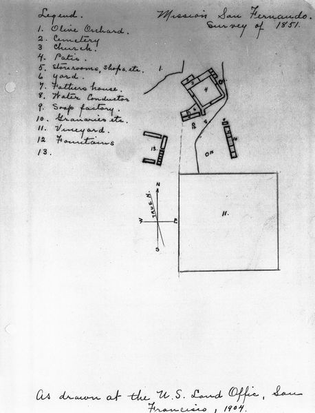
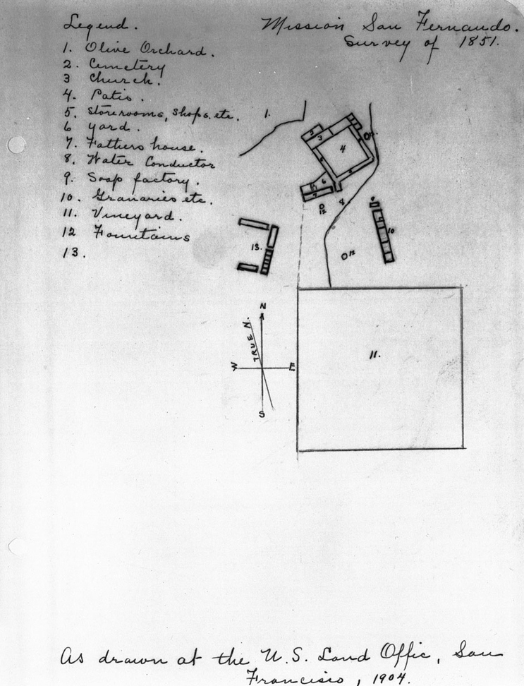
The document, drawn in 1904 from an 1851 survey, shows a square and other aerial polygons to the right, labeled with numbers. To the left, the numbers are identified by the following names: "1. Olive Orchard", "2. Cemetary", "3. Church", "4. Patio", "5. Storerooms, shops, etc.", "6. Yard", "7. Fattiero House", " 8. Water Conductor", "9. Soap factory", "10. Graineries, etc.", "11. Vineyard", "12. Fountains". Number thirteen is left blank, although it has a corresponding number on the map. A compass rose which includes true north is also shown. |
| Other versions
|
If there are other versions of this media on CZ, please list them here. |
| Using this image on CZ
|
Copy the code below to add this image to a Citizendium article, changing the size, alignment, and caption as necessary.
|
Image issue? Contact us via the email below.
Please send email to manager A T citizendium.org .
Licensing
This media, Mission Survey Map 1904.jpg, is in the public domain
This is a work of the United States Government, and as such is not afforded copyright protection under US law.
For further information see Title 17, Chapter 1, Section 105 of the US Code.
You may freely copy, distribute, display and perform this work, as well as make derivative and commercial works.
File history
Click on a date/time to view the file as it appeared at that time.
| Date/Time | Thumbnail | Dimensions | User | Comment | |
|---|---|---|---|---|---|
| current | 19:56, 11 March 2022 | | 743 × 972 (338 KB) | Maintenance script (talk | contribs) | == Summary == Importing file |
You cannot overwrite this file.
File usage
The following page uses this file: